PERIOD: Sunday, June 3 until Monday, June 11, 2012
DATE ISSUED: Saturday, June 2, 2012; 3:00 pm
SYNOPSIS:

Moist and unstable conditions associated with low pressures over Central America and the western Caribbean, a low-level surge of strong breeze across the central and western Caribbean in the ESE’ly trade winds, and divergence of the air in the upper levels, will results in thundery and showery weather persisting over Belize and adjacent areas during the next 10 days of June.
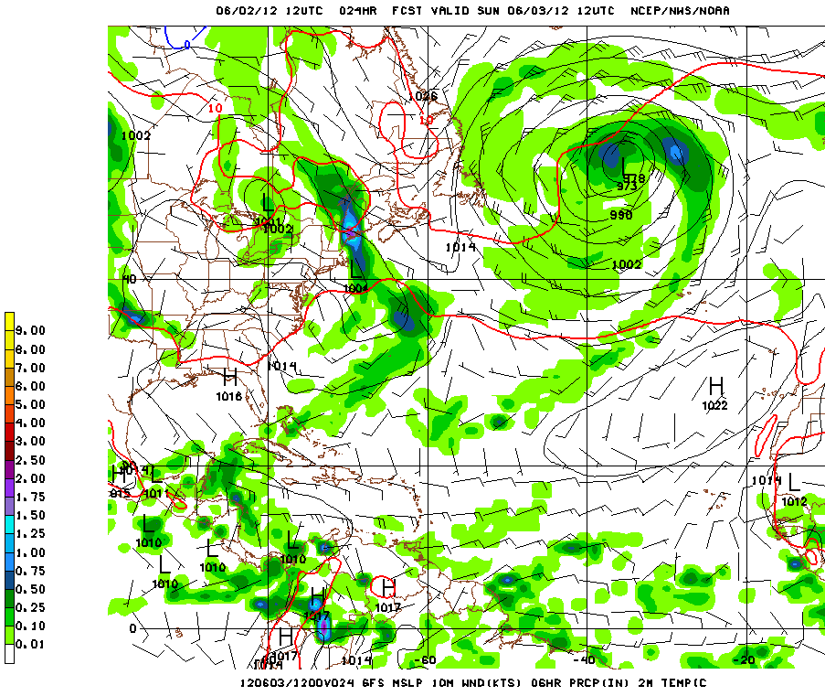
Figure 1 is the 24-hour GFS model forecast chart for 10 meter winds, 24-hour accumulated rainfall and the pressure patterns, valid for 6:00 am Sunday, June 3, 2012. It shows low pressures centers strung across the Pacific coast of Central America, with fresh E to ESE winds of 15 to 20 knots over the western Caribbean, and rainfall concentrated mostly over and offshore the Stann Creek, Belize and Corozal Districts on Saturday through Sunday morning. A trough of low pressure is also projected to remain over the extreme NW Caribbean and Yucatan through Monday.
Figure 2 shows the GFS model 132-hr projected vorticity pattern at 5,000 feet valid for Thursday evening, June 7, 2012, showing a trough of low pressure extending across the eastern Gulf of Mexico to coastal waters of Belize and the surge of strong low-level winds in the central and western Caribbean. This surge will enhance the convective activity generated by the low pressure trough in the NW Caribbean on Friday through most of the upcoming weekend.
Figure 3 shows the GFS model 24-hour rainfall totals ending at 6:00 am on Thursday, June 7, 2012. It depicts rainfall totals in the range of 0.25-0.50 of-an-inch for Wednesday and Wednesday night in the range of 0.25-0.50 of-an-inch, mostly over areas north of the Toledo District. Rainfall will be higher in the elevated areas of the Stann Creek and Cayo Districts, and favorable for quick runoff in some localities of these districts.
Belize Seven-day Outlook for Agriculture and Industry…
| Sun | Mon | Tue | Wed | Thu | Fri | Sat |
|---|---|---|---|---|---|---|
| June 3, 2012 | June 4, 2012 | June 5, 2012 | June 6, 2012 | June 7, 2012 | June 8, 2012 | June 9, 2012 |
| Cloudy with more out-breaks of showers & thunderstorms
mostly central & northern coasts Rainfall: 0.25-0.50 of-an-inch |
Cloudy with more out-breaks of showers & thunderstorms mostly central & northern coasts
Rainfall: 0.25-0.50 of-an-inch |
Cloudy with sunny spells. A few showers & thunderstorms
Rainfall: 0.10-0.25 of-an-inch |
Cloudy with sunny spells. A few showers & thunderstorms
Rainfall: 0.10-0.25 of-an- inch |
Cloudy with more out-breaks of showers & thunderstorms
mostly central & northern areas Rainfall: 0.25-0.50 of-an-inch
|
Cloudy with more out-breaks of showers & thunderstorms mostly central areas
Rainfall: 0.25-0.50 inch |
Cloudy with more out-breaks of showers & thunderstorms
mostly coastal northern half of mainland Rainfall: 0.50-0.75 of-an- inch |


Outlook for the Main Development Region (MDR) of the Tropical Atlantic Basin
Tropical cyclone formation is not expected in the Tropical Atlantic Basin during the next 48 hours.
Summary of Atlantic Basin 2012 Hurricane Season Forecast:
| Tropical Cyclones |
NHC 1981-2010 Seasonal Average |
CSU (Klotzbach & Gray) |
NOAA |
INSMET (Cuba) |
|---|---|---|---|---|
| Named Storms (NS) |
12 |
10 |
9-15 |
10 |
| Hurricanes (H) |
6 |
4 |
4-8 |
5 |
| Major Hurricanes |
3 |
2 |
1-3 |
— |
| Atlantic NS |
7.1 (INSMET) |
|
|
8 |
| Caribbean NS |
1.5 (INSMET) |
|
|
1 |
| Gulf of Mexico NS |
2.0 (INSMET) |
|
|
1 |
| Probability of at least one moving through the Caribbean Sea from Atlantic |
50% (INSMET) |
|
|
55% |
| Probability of at least one forming and reaching hurricane intensity within the Caribbean Sea |
43% (INSMET) |
|
|
15% |
Expected 2012 activity in the Atlantic Basin
Climate signals and evolving oceanic and atmospheric conditions, combined with dynamical model forecasts, indicate that a near-normal 2012 Atlantic hurricane season is most likely. This outlook calls for a 50% chance of a near-normal season, a 25% chance of an above-normal season, and a 25% chance of a below normal season.
An important measure of the total overall seasonal activity is NOAA’s Accumulated Cyclone Energy (ACE) index, which accounts for the intensity and duration of named storms and hurricanes during the season. This outlook indicates a 70% chance that the 2012 seasonal ACE range will be 65%-140% of the median. According to NOAA’s hurricane season classifications, an ACE value above 111% of the 1981-2010 median reflects an above-normal season. An ACE value below 71.4% of the median reflects a below-normal season.
Consistent with the expected ACE range, the 2012 Atlantic hurricane season is predicted to produce (with 70% probability for each range) 9-15 named storms, of which 4-8 are expected to become hurricanes, and 1-3 are expected to become major hurricanes. These ranges are centered near the 1981-2010 period averages of 12 named storms, 6 hurricanes and 3 major hurricanes.
(Source: NOAA, June 2012)


